Planet Alpha Direct Measurement GHG Project Registry
This registry does not inventory estimation-based greenhouse gas offsets
The only GHG registry featuring direct instrument measurement of CO2, CH4, and N2O
The PaC Registry is a no-cost, no-fee, listing of GHG emission reduction projects
Commercial and research data for GHG monitoring and isotopologues are included to ensure a harmonized framework
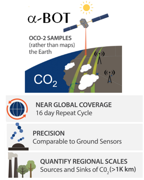
Phase I: Satellite Based Direct Carbon Flux
1. Alpha-Biosphere Offset Token products. PaC commercial projects based on satellite direct CO2 measurements that may include Moderate Resolution Imaging Spectroradiometer (MODIS) and overlapping Orbital Carbon Observatory 2 (OCO-2) column CO2 data
2. Research projects that report net carbon sequestration, and other greenhouse gases including isotopologues based on spectroscopic methods for quantification
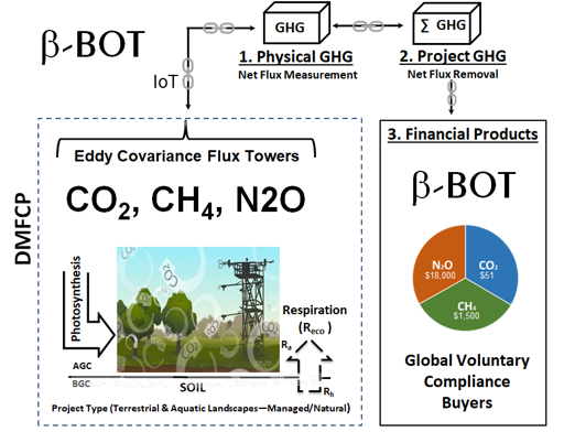
Phase II: Ground-Based GHG Sensors
Phase II, beta-Biosphere Offset Token products are based on in-country direct gas (CO2, CH4, N2O) monitoring of forests and anthropogenic landscapes primarily focused on forest restoration and management utilizing ground-based CO2 gas sensors. Eddy covariance supports ground-based and tower deployments to sample gas flux, resulting in net ecosystem exchange (NEE) for carbon as the basis for carbon offsets. A three-step process
The Results
Resulting data from Phases I and II are monetized as place-name products, serialized, and listed on an online sales and accounting platform to satisfy individual, corporate, governmental, and not-for-profit needs for Gaia products.
- The online accounting platform tracks sales and retirement of all products according to their stated terms of lifetime and other factors as may apply.
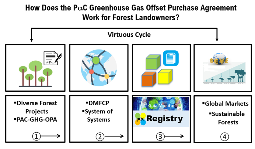
The Process
Forest carbon is valued in three steps, as shown in Figure 1 (below). Physical carbon is established by direct measurement, project carbon integrates the spatial and temporal boundaries of the project, and financial carbon is monetized and bundled in diverse portfolios for voluntary and compliance buyers. The figure is from: 2020. Direct measurement forest carbon protocol: a commercial system-of-systems to incentivize forest restoration and management. PeerJ 8:e8891 https://doi.org/10.7717/peerj.8891.


 Biodiversity (B) Avoided Carbon
 Gorilla Habitat (G) Avoided Carbon
 Methane (CH4)
 Indigenous Peoples (IP) Avoided Carbon
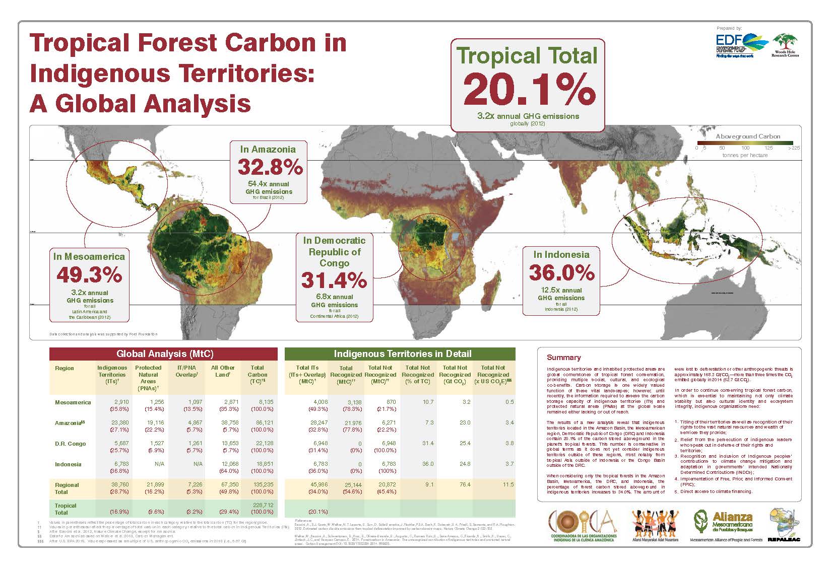
 Improved Forestry Management (IFM) Sequestration
 Afforestation (AF) Sequestration
 Agroforestry (GF) Sequestration
 The System of Systems (SoS)
 QuantumQarbon
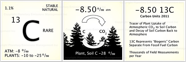
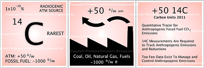
 Carbon isotopic analysis (IA)

 Carbon Dioxide (CO2)
 Working Forest Carbon Sequestration
 Eddy Covariance (EC)
 Soil Accumulation Chambers (SAC)
 Soil gas probes (SGP)
 Exsolvation of Dissolved CO2 (CO2(aqueous)) and CH4
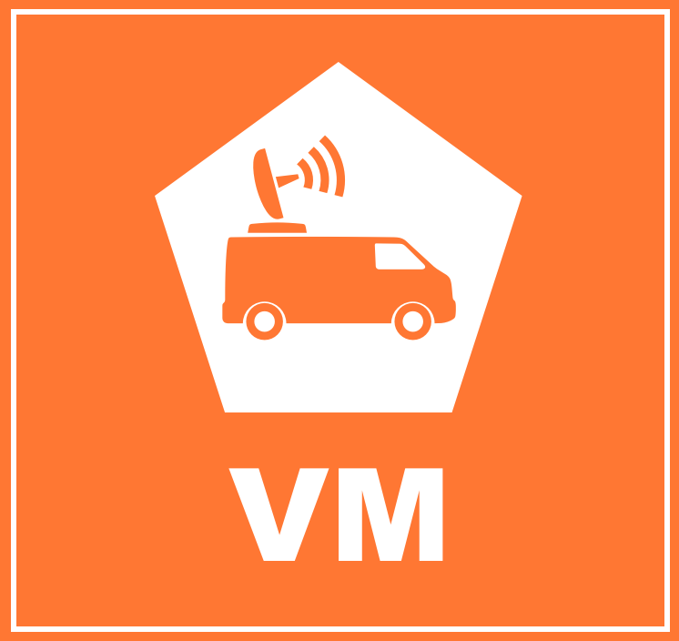 Vehicle Mounted Fast Response Gas Analyzers (VM)
 Unmanned Aerial Systems (UAS) and Remote Sensing (RS)
 A variety of UAS’s may be used in a project to record the status of forest conditions at low altitude (e.g., ~1,000 ft) on a routine basis, when a disturbance has occurred (e.g., hurricane, drought, timber operations) or for surveillance of forest activity by landowners or others accessing the site. Typical capabilities may include spectral imaging of the tree canopy and mapping functions to reveal differences along the flight path over time. In addition, UAS’s may also carry miniaturized gas sensors for CO2, CH4 and other atmospheric gases. The use of remote sensing (RS) for ecological research is well documented covering spectral bands for normalized difference vegetation index (NDVI), leaf evapotranspiration and other features of the biotic and abiotic project area.
 Flask Collection (FC)
 Nitrous Oxide (N2O)
 Sulfur Hexaflouride (SF6)
 Tree Plantation
 Perfluorocarbon (PFC)
 Water Vapor (H2O)