
Susan Murcott
VP, GLOBAL WATER SANITATION & HYGIENE PROGRAMS
Susan Murcott, an environmental engineer with a focus on water, is a Lecturer in D-Lab where, for the past 12 years, she has been teaching D-Lab-Water, Sanitation, Hygiene (EC.715/11.474J) and more recently, D-Lab: Water, Climate Change, and Health (EC.719/EC.789). In spring of 2017, she co-taught D-Lab: Earth.
She has led MIT student teams in over 25 countries spanning five continents. In 2014-2015, she led the water filter evaluation of the Comprehensive Initiative on Technology Evaluation (CITE), a five-year USAID-funded project, to evaluate technologies for the poor. From 2005 to the present, she founded and helped establish the non-profit organization, Pure Home Water, with Ghanaian partners, which has built a ceramic pot filter factory to provide safe drinking water in northern Ghana.
From 2002 to the present, she has been the principal investigator of a team, in partnership with the Environment and Public Health Organization in Kathmandu, Nepal, that invented and has widely disseminated the KanchanTM Arsenic Filter, as well as being involved in MIT-funded emergency relief following the 2015 Nepal earthquake. Current related project: Manufacturing and Marketing E. coli Test Kits to Promote Safely Managed Drinking Water and Improved Public Health in Nepal.
Murcott is the author of over 50 professional papers as well as the book Arsenic in the World: an International Sourcebook (IWA, 2012-Link).


 Biodiversity (B) Avoided Carbon
 Gorilla Habitat (G) Avoided Carbon
 Methane (CH4)
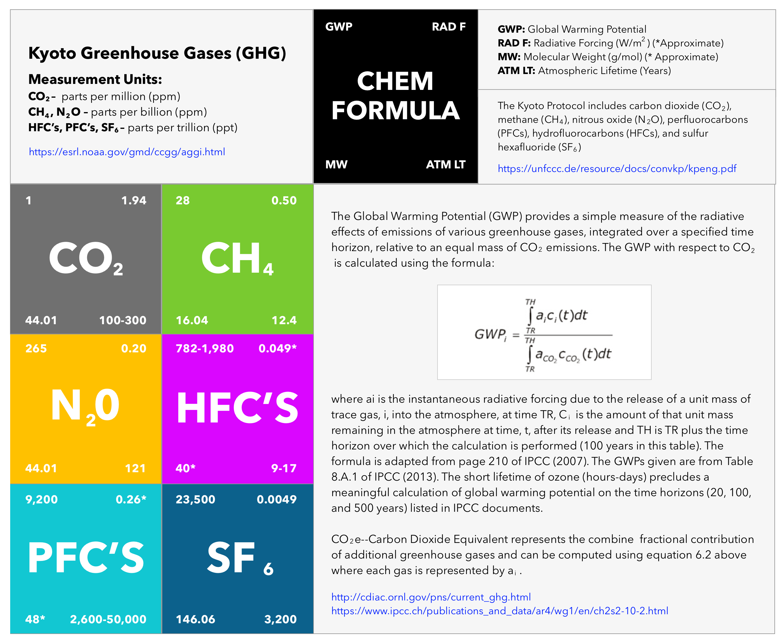
 Indigenous Peoples (IP) Avoided Carbon
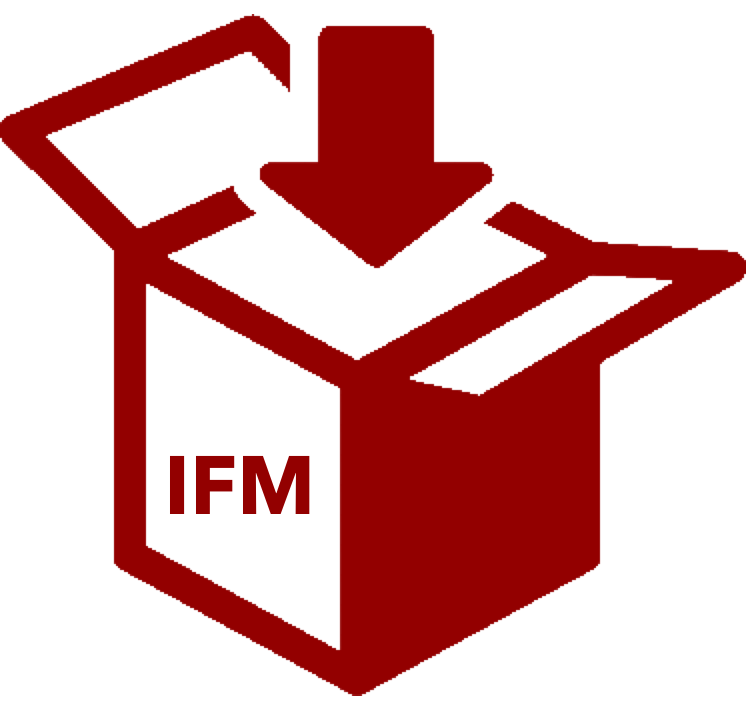 Improved Forestry Management (IFM) Sequestration
 Afforestation (AF) Sequestration
 Agroforestry (GF) Sequestration
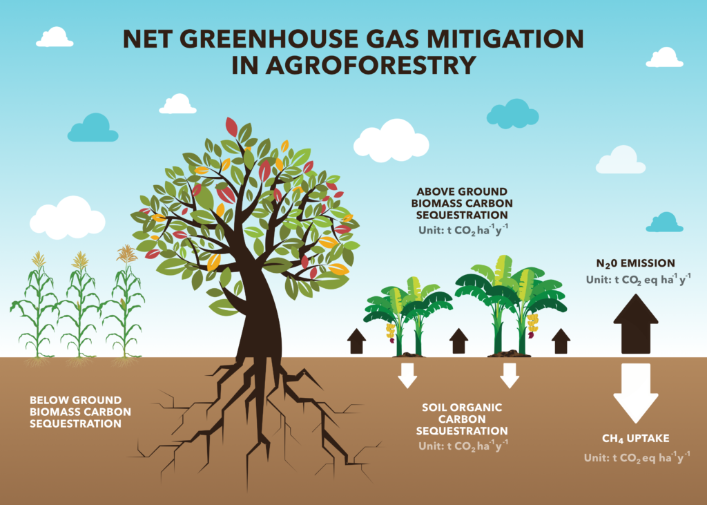
 The System of Systems (SoS)
 QuantumQarbon
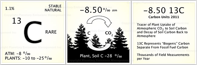
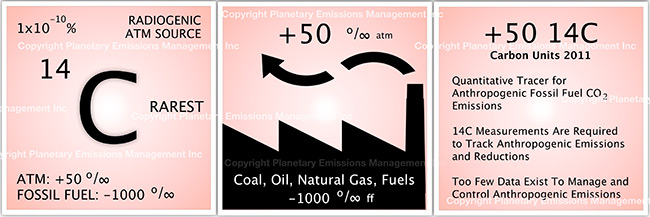
 Carbon isotopic analysis (IA)

 Carbon Dioxide (CO2)
 Working Forest Carbon Sequestration
 Eddy Covariance (EC)
 Soil Accumulation Chambers (SAC)
 Soil gas probes (SGP)
 Exsolvation of Dissolved CO2 (CO2(aqueous)) and CH4
 Vehicle Mounted Fast Response Gas Analyzers (VM)
 Unmanned Aerial Systems (UAS) and Remote Sensing (RS)
 A variety of UAS’s may be used in a project to record the status of forest conditions at low altitude (e.g., ~1,000 ft) on a routine basis, when a disturbance has occurred (e.g., hurricane, drought, timber operations) or for surveillance of forest activity by landowners or others accessing the site. Typical capabilities may include spectral imaging of the tree canopy and mapping functions to reveal differences along the flight path over time. In addition, UAS’s may also carry miniaturized gas sensors for CO2, CH4 and other atmospheric gases. The use of remote sensing (RS) for ecological research is well documented covering spectral bands for normalized difference vegetation index (NDVI), leaf evapotranspiration and other features of the biotic and abiotic project area.
 Flask Collection (FC)
 Nitrous Oxide (N2O)
 Sulfur Hexaflouride (SF6)
 Tree Plantation
 Perfluorocarbon (PFC)
 Water Vapor (H2O)